
Open Apple Maps to view the exact location of the project>>
Registration period: October 18 (Friday) to November 6 (Wednesday), 2024
Bidding period: November 19 (Tuesday) to November 26 (Tuesday), 2024
To participate in the bidding, you must complete the application procedures within the application period.
Sale of public property(6th sale)
Price Information
- Estimated price
- 5,130,000 yen
- Bid security
- 513,000 yen
Schedule
- Application Period
- October 18, 2024 13:00 to November 6, 2024 14:00
- Bidding period
- November 19, 2024 13:00 to November 26, 2024 13:00
- Deadline for payment of sale price
- January 6, 2025 17:00
- Contract signing period
- November 28, 2024 17:00
Payment Methods
- Bid security payment method
- Bank transfer, etc.
- Payment method of sale price
- Direct holding by bank transfer
- Auction Type
- Sale of public property
- Implementation
- Bidding Form
- Name of implementing agency
- Tokushima Prefecture
- Selling Category Number
- 05
- Payment Methods
- Direct holding by bank transfer
- Contract signing period
- November 28, 2024 17:00
Object Information
- Object Type
- Homestead
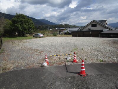
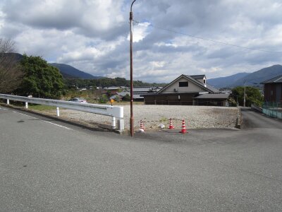
- Location of the object
- Tokushima Prefecture
Basic real estate information
- location
- Tokushima Prefecture Mima City Mima Town Aza Sakaime 183 No. 15
- Transportation, nearest station, etc.
- JR Tokushima Line Eguchi Station about 3.2 km
Land Information
- Land area (㎡)
- 781.26 (measured)
- Land
- Homestead
- Urban planning area
- Outside the urban planning area
- Use area
- none
- Fire protection area
- unknown
- Other restrictions of laws and regulations
- Sand Control Law (Designated Sand Control Area)
- Terrain, etc.
- Irregular trapezoid
- Width, connection condition
-
South side: 4.2 to 8.0m wide, paved with the city road (city road Meima No. 20)
And the west side of the structure: width 8.0 to 8.7m paved with the city road (city road Meima line 17) - Supply processing facilities
- Electrical and water supply can be introduced
- Other land-related property information
-
・The ground is generally flat, but it is about 0.5 to 1.5 meters higher than the south side of the city road, and about 0.3 meters lower near the entrance at the southwest end.
Reference: ・The land in question has been used as a public hall site until the 2nd fiscal year of Reiwa.
・The adjacent land is designated as a designated erosion control site, and the western part of the site may be designated as a designated erosion control site
When remodeling the side ditches within the site, it may be necessary to consult with the Sand and Earthquake Control Division.
・When carrying out activities prescribed in Article 4 of the Enforcement Ordinance of the Sand Control Act within designated sand control areas, prior permission from the Governor of Tokushima Prefecture is required.
Contact information for inquiries about the property
- Production Administration
- Tokushima Prefecture
- Responsible Department
- Facilities Optimization Responsible, Finance and Management Division
- email address
- kanzaika@pref.tokushima.lg.jp
- Telephone
- 088-621-2068
- Processing time
- 9:00am to 5:00pm
Past productions
- 1st time
- 5.13 million yen (unsold as of 2022.07.05)
- 2nd time
- 5.13 million yen (unsold as of 2022.11.29)
- 3rd time
- 5.13 million yen (unsold as of 2023.07.04)
- 4th
- 5.13 million yen (unsold as of 2023.11.28)
- No. 5
- 5.13 million yen (unsold as of 2024.07.02)